Summary
Digos (en cebuano Dakbayan sa Digos, en filipino Lungsod ng Digos, en inglés Digos City) es una ciudad filipina (Component ) y un municipio de segunda categoría, situado en la parte sudeste de la isla de Mindanao. Capital de la provincia de Dávao del Sur situada en la Región Administrativa de Región de Dávao en cebuano Rehiyon sa Davao, también denominada Región XI. Para las elecciones está encuadrado en el Primer Distrito Electoral.[2] Forma parte de Área Metropolitana de Dávao (Metro Davao).
| Digos | ||
|---|---|---|
| Ciudad | ||
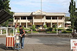
 Palacio municipal
| ||
|
Localización de Digos en Filipinas | ||
 | ||
| Coordenadas | 6°45′N 125°21′E / 6.75, 125.35 | |
| Entidad | Ciudad | |
| • País |
| |
| • Región | Dávao | |
| • Provincia | Dávao del Sur | |
| Superficie | ||
| • Total | 287,1 km² | |
| Altitud | ||
| • Media | 190 m s. n. m. | |
| Población (2024) | ||
| • Total | 192 063 hab. | |
| • Densidad | 668,98 hab./km² | |
| Huso horario | UTC+08:00 | |
| Código postal | 8002[1] | |
| Prefijo telefónico | 82 | |
| Código ZIP | 112403 | |
| Sitio web oficial | ||
Barrios
editarEl municipio de Digos se divide, a los efectos administrativos, en 26 barangayes o barrios, conforme a la siguiente relación:[3][4]
Historia
editarEl actual territorio de la provincia de Davo Oriental fue parte de la provincia de Caraga durante la mayor parte del Imperio español en Asia y Oceanía (1520-1898). A principios del siglo XX la isla de Mindanao se hallaba dividida en siete distritos o provincias.
El Distrito 4º de Dávao, llamado hasta 1858 provincia de Nueva Guipúzcoa, tenía por capital el pueblo de Dávao e incluía la Comandancia de Mati.[5]
El 15 de julio de 2000 le fue concedida la Carta de Ciudad (Charter of the City of Digos) con los siguientes límites:[6]
"...Linda al este, línea 1-2-3 con el municipio de Santa Cruz; al sur, línea 3-4 con el Golfo de Davao; al sur, linea 4-5 con el municipio de Hagonoy; al suroeste, línea 5-6 con el municipio de Matan-ao; al oeste, línea 6-7 con el municipio de Bansalán; al norosete, línea 7-8-1 con el municipio de Santa Cruz..."Charter of the City of Digos.[7]
Referencias
editar- ↑ Worldpostalcodes.org, código postal n.º 8002.
- ↑ «ORDINANCE APPORTIONING THE SEATS OF THE HOUSE OF REPRESENTATIVES OF THE CONGRESS OF THE PHILIPPINES TO THE DIFFERENT LEGISLATIVE DISTRICTS IN PROVINCES AND CITIES AND THE METROPOLITAN MANILA AREA.». Archivado desde el original el 3 de noviembre de 2013. Consultado el 29 de diciembre de 2013.
- ↑ Bajo el Código de Gobierno Local de 1991, los antiguos barrios de Filipinas han sido denominados como barangays.
- ↑ «National Statistical Coordination Board. Consultado del 28 de octubre de 2013.». Archivado desde el original el 29 de octubre de 2013. Consultado el 28 de octubre de 2013.
- ↑ El Archipiélago Filipino. Colección de datos. Por algunos padres de la Misión de la Compañía de Jesús en estas islas. Tomo I, Washington, Imprenta del Gobierno, 1900, página 128.
- ↑ «REPUBLIC ACT NO. 8798 AN ACT CONVERTING THE MUNICIPALITY OF DIGOS, DAVAO DEL SUR PROVINCE, INTO A COMPONENT CITY TO BE KNOWN AS THE CITY OF DIGOS». Archivado desde el original el 1 de noviembre de 2013. Consultado el 30 de octubre de 2013.
- ↑ Beginning at a point marked “1″ on plan as a peak point of 1582 elevation; thence Southerly along the watershed line through the ridge of Higpit Range to point 2; thence Southeasterly along Quibanban (Sirawilan Creek) to point 3; thence Southerly, along the shoreline of Davao Gulf to point 4; thence Due West, along Northern boundary line of Municipality of Hagonoy to point 5; thence Northeasterly, along Eastern boundary line of Matan-ao point 6; thence Northerly, along Mati River to watershed line at the Peak of Mt. Apo as point 7; thence Southeasterly, from the peak of Mt. Apo to the source of the first branch of Tagulaya River downstream and to its fourth junction as point 8; thence Southerly, along the fourth branch of Tagulaya River, upstream to its source and traight to the peak of 1582 elevation, the point of beginning; Containing an area of twenty-eight thousand seven hundred ten (28,710) hectares more or less.
- Wikimedia Commons alberga una categoría multimedia sobre Digos.


